


Duranus Calençon Col de l'Autaret Ruines Rocca Sparviera Ravin de Caussimière

GrouGary
User
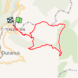

Length
10.2 km

Max alt
1275 m

Uphill gradient
864 m
Km-Effort
22 km

Min alt
427 m

Downhill gradient
860 m
Boucle
Yes
Creation date :
2017-05-08 00:00:00.0
Updated on :
2017-05-08 00:00:00.0
5h26
Difficulty : Easy

FREE GPS app for hiking
 SityTrail
IGN / Geographical institutes
SityTrail Plus
The world is yours!
About
Trail Walking of 10.2 km to be discovered at Provence-Alpes-Côte d'Azur, Maritime Alps, Utelle. This trail is proposed by GrouGary.
Description
Circuit prévu pour la Cime de Roccassiera en variante.
Positioning
Country:
France
Region :
Provence-Alpes-Côte d'Azur
Department/Province :
Maritime Alps
Municipality :
Utelle
Location:
Unknown
Start:(Dec)
Start:(UTM)
360366 ; 4862702 (32T) N.
Comments