


ANGLEUR_SPRIMONT_24000m_D 730

Phfery
User
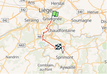

Length
24 km

Max alt
282 m

Uphill gradient
725 m
Km-Effort
33 km

Min alt
63 m

Downhill gradient
524 m
Boucle
No
Creation date :
2017-05-09 00:00:00.0
Updated on :
2017-05-09 00:00:00.0
3h10
Difficulty : Difficult

FREE GPS app for hiking
 SityTrail
IGN / Geographical institutes
SityTrail Plus
The world is yours!
About
Trail Running of 24 km to be discovered at Wallonia, Liège, Liège. This trail is proposed by Phfery.
Points of interest


Positioning
Country:
Belgium
Region :
Wallonia
Department/Province :
Liège
Municipality :
Liège
Location:
Angleur
Start:(Dec)
Start:(UTM)
683931 ; 5610044 (31U) N.
Comments