


2017 05 09 raymond

michelbauby
User
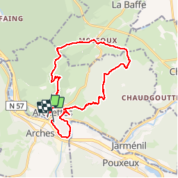

Length
16 km

Max alt
444 m

Uphill gradient
228 m
Km-Effort
19 km

Min alt
343 m

Downhill gradient
227 m
Boucle
No
Creation date :
2017-05-09 00:00:00.0
Updated on :
2017-05-09 00:00:00.0
3h52
Difficulty : Medium

FREE GPS app for hiking
 SityTrail
IGN / Geographical institutes
SityTrail Plus
The world is yours!
About
Trail Other activity of 16 km to be discovered at Grand Est, Vosges, Archettes. This trail is proposed by michelbauby.
Positioning
Country:
France
Region :
Grand Est
Department/Province :
Vosges
Municipality :
Archettes
Location:
Unknown
Start:(Dec)
Start:(UTM)
316320 ; 5332957 (32U) N.
Comments