


Pignans rando

Sugg
User
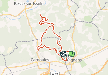

Length
22 km

Max alt
386 m

Uphill gradient
477 m
Km-Effort
29 km

Min alt
181 m

Downhill gradient
471 m
Boucle
Yes
Creation date :
2019-03-22 16:58:24.171
Updated on :
2019-03-22 16:58:24.268
6h55
Difficulty : Unknown

FREE GPS app for hiking
 SityTrail
IGN / Geographical institutes
SityTrail Plus
The world is yours!
About
Trail Walking of 22 km to be discovered at Provence-Alpes-Côte d'Azur, Var, Pignans. This trail is proposed by Sugg.
Positioning
Country:
France
Region :
Provence-Alpes-Côte d'Azur
Department/Province :
Var
Municipality :
Pignans
Location:
Unknown
Start:(Dec)
Start:(UTM)
274649 ; 4798073 (32T) N.
Comments