


Vars: Sommet de Peinier

lviallet
User
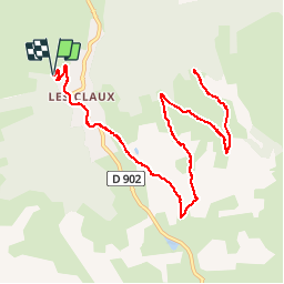

Length
14.8 km

Max alt
2257 m

Uphill gradient
475 m
Km-Effort
21 km

Min alt
1855 m

Downhill gradient
476 m
Boucle
Yes
Creation date :
2017-05-12 00:00:00.0
Updated on :
2017-05-12 00:00:00.0
2h45
Difficulty : Unknown

FREE GPS app for hiking
 SityTrail
IGN / Geographical institutes
SityTrail Plus
The world is yours!
About
Trail Walking of 14.8 km to be discovered at Provence-Alpes-Côte d'Azur, Hautes-Alpes, Vars. This trail is proposed by lviallet.
Positioning
Country:
France
Region :
Provence-Alpes-Côte d'Azur
Department/Province :
Hautes-Alpes
Municipality :
Vars
Location:
Unknown
Start:(Dec)
Start:(UTM)
315597 ; 4938364 (32T) N.
Comments