


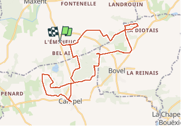
12.05.2017 - CAMPEL MOMO

babeth35
User

Length
23 km

Max alt
140 m

Uphill gradient
305 m
Km-Effort
27 km

Min alt
74 m

Downhill gradient
306 m
Boucle
Yes
Creation date :
2017-05-12 00:00:00.0
Updated on :
2020-07-20 15:17:50.484
6h13
Difficulty : Easy

FREE GPS app for hiking
 SityTrail
IGN / Geographical institutes
SityTrail Plus
The world is yours!
About
Trail Walking of 23 km to be discovered at Brittany, Ille-et-Vilaine, Maxent. This trail is proposed by babeth35.
Positioning
Country:
France
Region :
Brittany
Department/Province :
Ille-et-Vilaine
Municipality :
Maxent
Location:
Unknown
Start:(Dec)
Start:(UTM)
573454 ; 5312671 (30T) N.
Comments