


Le pilon de St Clément

ARPF
User
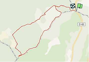

Length
11.8 km

Max alt
698 m

Uphill gradient
544 m
Km-Effort
19 km

Min alt
422 m

Downhill gradient
544 m
Boucle
Yes
Creation date :
2017-05-15 00:00:00.0
Updated on :
2017-05-15 00:00:00.0
4h00
Difficulty : Medium

FREE GPS app for hiking
 SityTrail
IGN / Geographical institutes
SityTrail Plus
The world is yours!
About
Trail Walking of 11.8 km to be discovered at Provence-Alpes-Côte d'Azur, Var, Rocbaron. This trail is proposed by ARPF.
Description
P2 T1 Maurice
Positioning
Country:
France
Region :
Provence-Alpes-Côte d'Azur
Department/Province :
Var
Municipality :
Rocbaron
Location:
Unknown
Start:(Dec)
Start:(UTM)
262264 ; 4796812 (32T) N.
Comments