


bailleval 20km

dartoisclaude
User
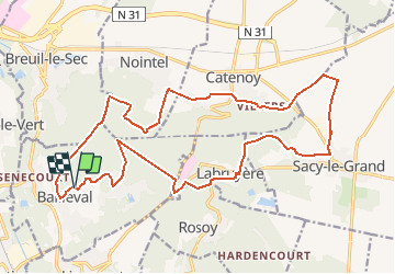

Length
21 km

Max alt
162 m

Uphill gradient
444 m
Km-Effort
27 km

Min alt
39 m

Downhill gradient
438 m
Boucle
Yes
Creation date :
2017-05-15 00:00:00.0
Updated on :
2017-05-15 00:00:00.0
5h39
Difficulty : Very difficult

FREE GPS app for hiking
 SityTrail
IGN / Geographical institutes
SityTrail Plus
The world is yours!
About
Trail Walking of 21 km to be discovered at Hauts-de-France, Oise, Bailleval. This trail is proposed by dartoisclaude.
Description
départ Bailleval parking cimetière
Positioning
Country:
France
Region :
Hauts-de-France
Department/Province :
Oise
Municipality :
Bailleval
Location:
Unknown
Start:(Dec)
Start:(UTM)
460832 ; 5466419 (31U) N.
Comments