


69 ECHALAS Combe d'enfer au Crêt des moussieres

trietsch
User
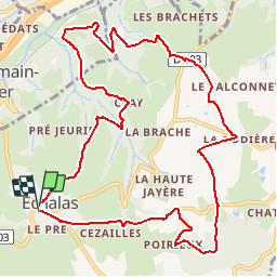

Length
12.4 km

Max alt
475 m

Uphill gradient
348 m
Km-Effort
17 km

Min alt
205 m

Downhill gradient
346 m
Boucle
Yes
Creation date :
2017-05-15 00:00:00.0
Updated on :
2020-01-04 20:29:06.864
3h37
Difficulty : Medium

FREE GPS app for hiking
 SityTrail
IGN / Geographical institutes
SityTrail Plus
The world is yours!
About
Trail Walking of 12.4 km to be discovered at Auvergne-Rhône-Alpes, Rhône, Échalas. This trail is proposed by trietsch.
Description
balisage jaune et blanc
sens aiguille de la montre
Départ place de l'Eglise
Positioning
Country:
France
Region :
Auvergne-Rhône-Alpes
Department/Province :
Rhône
Municipality :
Échalas
Location:
Unknown
Start:(Dec)
Start:(UTM)
633912 ; 5045724 (31T) N.
Comments