


les abeilles Cuers

bernir
User
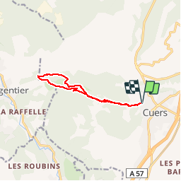

Length
10.6 km

Max alt
428 m

Uphill gradient
330 m
Km-Effort
15 km

Min alt
152 m

Downhill gradient
330 m
Boucle
Yes
Creation date :
2017-05-20 00:00:00.0
Updated on :
2017-05-20 00:00:00.0
3h18
Difficulty : Easy

FREE GPS app for hiking
 SityTrail
IGN / Geographical institutes
SityTrail Plus
The world is yours!
About
Trail Walking of 10.6 km to be discovered at Provence-Alpes-Côte d'Azur, Var, Cuers. This trail is proposed by bernir.
Positioning
Country:
France
Region :
Provence-Alpes-Côte d'Azur
Department/Province :
Var
Municipality :
Cuers
Location:
Unknown
Start:(Dec)
Start:(UTM)
261813 ; 4791704 (32T) N.
Comments