


Cabrieres d'Aigues - etang de la Bonde

mhetpierre
User
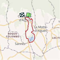

Length
9.4 km

Max alt
435 m

Uphill gradient
167 m
Km-Effort
11.6 km

Min alt
328 m

Downhill gradient
167 m
Boucle
Yes
Creation date :
2018-08-18 15:29:49.004
Updated on :
2018-08-18 15:29:49.004
2h51
Difficulty : Easy

FREE GPS app for hiking
 SityTrail
IGN / Geographical institutes
SityTrail Plus
The world is yours!
About
Trail Walking of 9.4 km to be discovered at Provence-Alpes-Côte d'Azur, Vaucluse, Cabrières-d'Aigues. This trail is proposed by mhetpierre.
Positioning
Country:
France
Region :
Provence-Alpes-Côte d'Azur
Department/Province :
Vaucluse
Municipality :
Cabrières-d'Aigues
Location:
Unknown
Start:(Dec)
Start:(UTM)
701052 ; 4850694 (31T) N.
Comments