


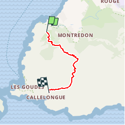
malmousque callelongue

fhascoet
User

Length
3.4 km

Max alt
345 m

Uphill gradient
322 m
Km-Effort
7.8 km

Min alt
9 m

Downhill gradient
344 m
Boucle
No
Creation date :
2017-05-22 00:00:00.0
Updated on :
2017-05-22 00:00:00.0
1h32
Difficulty : Difficult

FREE GPS app for hiking
 SityTrail
IGN / Geographical institutes
SityTrail Plus
The world is yours!
About
Trail Walking of 3.4 km to be discovered at Provence-Alpes-Côte d'Azur, Bouches-du-Rhône, Marseille. This trail is proposed by fhascoet.
Description
quelque passage où il faut mettre les mains
retour au départ avec le bus 20
Photos


Positioning
Country:
France
Region :
Provence-Alpes-Côte d'Azur
Department/Province :
Bouches-du-Rhône
Municipality :
Marseille
Location:
8th Arrondissement
Start:(Dec)
Start:(UTM)
691192 ; 4788984 (31T) N.
Comments