


FBBMP. Reid

mozzipsc
User
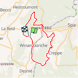

Length
13.5 km

Max alt
394 m

Uphill gradient
347 m
Km-Effort
18.2 km

Min alt
218 m

Downhill gradient
347 m
Boucle
Yes
Creation date :
2017-05-22 00:00:00.0
Updated on :
2017-05-22 00:00:00.0
3h55
Difficulty : Very easy

FREE GPS app for hiking
 SityTrail
IGN / Geographical institutes
SityTrail Plus
The world is yours!
About
Trail Walking of 13.5 km to be discovered at Wallonia, Liège, Theux. This trail is proposed by mozzipsc.
Description
TRès beau parcours à travers forêt, bois et campagne - dommage qu'on ne pourra pas la refaire, passant par un bois privé ! mais facilement contournable :-)
Positioning
Country:
Belgium
Region :
Wallonia
Department/Province :
Liège
Municipality :
Theux
Location:
La Reid
Start:(Dec)
Start:(UTM)
699745 ; 5596146 (31U) N.
Comments