Trail Walking Mutzig - Les sanctuaires autour de Mutzig - Photo

Les sanctuaires autour de Mutzig

© OpenStreetMap contributors
Length
Length
13.6 km
Max alt
Max alt
301 m
Uphill gradient
Uphill gradient
322 m
Km-Effort
Km-Effort  
17.9 km
Min alt
Min alt
181 m
Downhill gradient
Downhill gradient
322 m
Boucle
Boucle
Yes
Creation date :
2017-05-21 00:00:00.0
Updated on :
2017-05-21 00:00:00.0

(1 Reviews)

Walking
Walking
5h00
Difficulty : Medium

Scan this QR Code to open this trail in the SityTrail application

FREE GPS app for hiking

Logo SityTrail SityTrail

IGN / Geographical institutes

Download SityTrail from the App Store Download SityTrail from Google Play

Logo SityTrail SityTrail Plus

The world is yours!

Download SityTrail from the App Store Download SityTrail from Google Play Download SityTrail on Huawei AppGallery

About

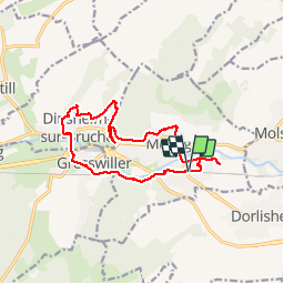
Trail Walking of 13.6 km to be discovered at Grand Est, Bas-Rhin, Mutzig. This trail is proposed by VacheKiri67.

Description

Faite le 21/05/2017 avec notre fils Théo de 12 ans. D'après "Les sanctuaires autour de Mutzig - OT Molsheim".
Durée indiquée pour le circuit : 4h30.
Balisage Anneau jaune. Départ Gare de Mutzig.
Voir http://www.ot-molsheim-mutzig.com/detours-religieux/rando-sanctuaires-mutzig.pdf.

Elevation profile

Photos

28 photos in total. Please click on a photo to see them all in the gallery.

Positioning

Country:
France
Region :
Grand Est
Department/Province :
Bas-Rhin
Municipality :
Mutzig
Location:
Unknown
Start:(UTM)
386435 ; 5376787 (32U) N.

Comments

Please log in to post a review or rate the element


Beau parcours avec de belles vues et notamment sur le sentier des roches au dessus de Mutzig.


Close
My subscriptions