


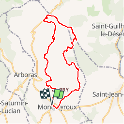
Herault - Montpeyroux La Croix de Fer La Grotte des Fees Dondone 18km 581m

RandoVal
User

Length
17.4 km

Max alt
561 m

Uphill gradient
592 m
Km-Effort
25 km

Min alt
122 m

Downhill gradient
592 m
Boucle
Yes
Creation date :
2018-09-12 19:08:49.898
Updated on :
2018-09-12 19:08:49.908
5h19
Difficulty : Difficult

FREE GPS app for hiking
 SityTrail
IGN / Geographical institutes
SityTrail Plus
The world is yours!
About
Trail Walking of 17.4 km to be discovered at Occitania, Hérault, Montpeyroux. This trail is proposed by RandoVal.
Description
Boucle dans le massif de St-Guilhem-le-Desert. Parking du couvent, sens anti-horaire.
Positioning
Country:
France
Region :
Occitania
Department/Province :
Hérault
Municipality :
Montpeyroux
Location:
Unknown
Start:(Dec)
Start:(UTM)
540666 ; 4838178 (31T) N.
Comments