


Forêt de Cheptainville - 5,3 km - 1h30

Bastet
User
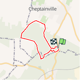

Length
5.3 km

Max alt
160 m

Uphill gradient
101 m
Km-Effort
6.6 km

Min alt
87 m

Downhill gradient
100 m
Boucle
Yes
Creation date :
2018-05-13 00:00:00.0
Updated on :
2018-05-13 00:00:00.0
1h26
Difficulty : Very easy

FREE GPS app for hiking
 SityTrail
IGN / Geographical institutes
SityTrail Plus
The world is yours!
About
Trail Walking of 5.3 km to be discovered at Ile-de-France, Essonne, Cheptainville. This trail is proposed by Bastet.
Positioning
Country:
France
Region :
Ile-de-France
Department/Province :
Essonne
Municipality :
Cheptainville
Location:
Unknown
Start:(Dec)
Start:(UTM)
446365 ; 5376153 (31U) N.
Comments
