


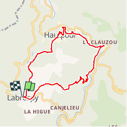
Labrespy, Hautpoul, St-Pierre des Plots

Jean-Phi81
User

Length
9 km

Max alt
628 m

Uphill gradient
358 m
Km-Effort
13.8 km

Min alt
346 m

Downhill gradient
362 m
Boucle
Yes
Creation date :
2017-05-24 00:00:00.0
Updated on :
2017-05-24 00:00:00.0
3h01
Difficulty : Medium

FREE GPS app for hiking
 SityTrail
IGN / Geographical institutes
SityTrail Plus
The world is yours!
About
Trail Walking of 9 km to be discovered at Occitania, Tarn, Mazamet. This trail is proposed by Jean-Phi81.
Positioning
Country:
France
Region :
Occitania
Department/Province :
Tarn
Municipality :
Mazamet
Location:
Unknown
Start:(Dec)
Start:(UTM)
448722 ; 4812098 (31T) N.
Comments
belle randonnée facile à faire même en famille.