


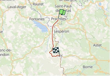
GR 70 Stevenson 4 Pradelles - Luc

mhetpierre
User

Length
22 km

Max alt
1236 m

Uphill gradient
429 m
Km-Effort
28 km

Min alt
899 m

Downhill gradient
575 m
Boucle
No
Creation date :
2018-08-18 15:29:48.175
Updated on :
2018-08-18 15:29:48.175
5h18
Difficulty : Medium

FREE GPS app for hiking
 SityTrail
IGN / Geographical institutes
SityTrail Plus
The world is yours!
About
Trail Walking of 22 km to be discovered at Auvergne-Rhône-Alpes, Haute-Loire, Pradelles. This trail is proposed by mhetpierre.
Positioning
Country:
France
Region :
Auvergne-Rhône-Alpes
Department/Province :
Haute-Loire
Municipality :
Pradelles
Location:
Unknown
Start:(Dec)
Start:(UTM)
569862 ; 4957723 (31T) N.
Comments