


Pas de l'Allier court

bob2023
User
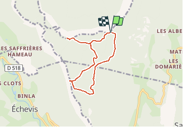

Length
6.7 km

Max alt
1259 m

Uphill gradient
222 m
Km-Effort
9.6 km

Min alt
1116 m

Downhill gradient
224 m
Boucle
Yes
Creation date :
2018-08-26 08:32:02.706
Updated on :
2018-08-26 08:32:02.714
2h25
Difficulty : Easy

FREE GPS app for hiking
 SityTrail
IGN / Geographical institutes
SityTrail Plus
The world is yours!
About
Trail Walking of 6.7 km to be discovered at Auvergne-Rhône-Alpes, Drôme, Saint-Julien-en-Vercors. This trail is proposed by bob2023.
Description
Version courte
Positioning
Country:
France
Region :
Auvergne-Rhône-Alpes
Department/Province :
Drôme
Municipality :
Saint-Julien-en-Vercors
Location:
Unknown
Start:(Dec)
Start:(UTM)
690097 ; 4990776 (31T) N.
Comments