


MURAT (Cantal)

AndreLACOMBE
User
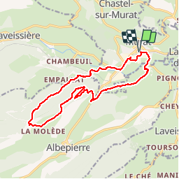

Length
16.4 km

Max alt
1337 m

Uphill gradient
595 m
Km-Effort
24 km

Min alt
885 m

Downhill gradient
595 m
Boucle
Yes
Creation date :
2017-05-28 00:00:00.0
Updated on :
2017-05-28 00:00:00.0
6h32
Difficulty : Unknown

FREE GPS app for hiking
 SityTrail
IGN / Geographical institutes
SityTrail Plus
The world is yours!
About
Trail Walking of 16.4 km to be discovered at Auvergne-Rhône-Alpes, Cantal, Murat. This trail is proposed by AndreLACOMBE.
Description
Col de la Molède
Positioning
Country:
France
Region :
Auvergne-Rhône-Alpes
Department/Province :
Cantal
Municipality :
Murat
Location:
Murat
Start:(Dec)
Start:(UTM)
489653 ; 4995115 (31T) N.
Comments
beau parcours