


dag 3

timadams
User
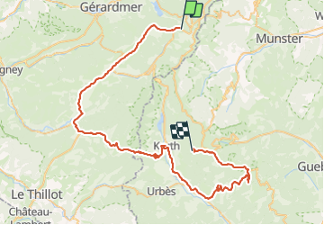

Length
67 km

Max alt
1239 m

Uphill gradient
1634 m
Km-Effort
88 km

Min alt
411 m

Downhill gradient
1447 m
Boucle
No
Creation date :
2018-04-16 15:27:23.643
Updated on :
2018-04-16 15:27:23.643
8h23
Difficulty : Difficult

FREE GPS app for hiking
 SityTrail
IGN / Geographical institutes
SityTrail Plus
The world is yours!
About
Trail Other activity of 67 km to be discovered at Grand Est, Vosges, Xonrupt-Longemer. This trail is proposed by timadams.
Positioning
Country:
France
Region :
Grand Est
Department/Province :
Vosges
Municipality :
Xonrupt-Longemer
Location:
Unknown
Start:(Dec)
Start:(UTM)
350009 ; 5323804 (32U) N.
Comments