


2017-05-31.gpx

georgein
User
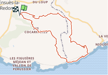

Length
10.7 km

Max alt
237 m

Uphill gradient
304 m
Km-Effort
14.8 km

Min alt
20 m

Downhill gradient
309 m
Boucle
Yes
Creation date :
2019-08-04 09:22:01.852
Updated on :
2020-01-31 20:32:06.943
--
Difficulty : Unknown

FREE GPS app for hiking
 SityTrail
IGN / Geographical institutes
SityTrail Plus
The world is yours!
About
Trail Walking of 10.7 km to be discovered at Provence-Alpes-Côte d'Azur, Bouches-du-Rhône, Ensuès-la-Redonne. This trail is proposed by georgein.
Positioning
Country:
France
Region :
Provence-Alpes-Côte d'Azur
Department/Province :
Bouches-du-Rhône
Municipality :
Ensuès-la-Redonne
Location:
Unknown
Start:(Dec)
Start:(UTM)
679098 ; 4802254 (31T) N.
Comments