


parcours de chatenois

nicolasdresse
User
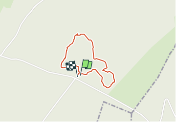

Length
1.3 km

Uphill gradient
18 m
Km-Effort
1.6 km

Downhill gradient
18 m
Boucle
Yes
Creation date :
2018-09-29 20:52:17.899
Updated on :
2018-09-29 20:52:17.911
30m
Difficulty : Unknown

FREE GPS app for hiking
 SityTrail
IGN / Geographical institutes
SityTrail Plus
The world is yours!
About
Trail Walking of 1.3 km to be discovered at Bourgogne-Franche-Comté, Haute-Saône, Châtenois. This trail is proposed by nicolasdresse.
Photos

Positioning
Country:
France
Region :
Bourgogne-Franche-Comté
Department/Province :
Haute-Saône
Municipality :
Châtenois
Location:
Unknown
Start:(Dec)
Start:(UTM)
299532 ; 5284659 (32T) N.
Comments