


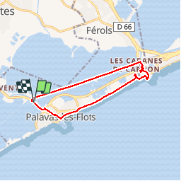
RP34 PALAVAS LES FLOTS - CARNON

jeff66
User


2h05
Difficulty : Medium

FREE GPS app for hiking
 SityTrail
IGN / Geographical institutes
SityTrail Plus
The world is yours!
About
Trail Cycle of 11.9 km to be discovered at Occitania, Hérault, Palavas-les-Flots. This trail is proposed by jeff66.
Description
RP34 PALAVAS LES FLOTS - CARNON, les 4 canaux, le long du canal du Rhône à Sète, les cabanes de CARNON, pont de Carnon, retour par le front de mer, les capitaineries et Ports, Carnon Ouest, PALAVAS, le 04.06.2017
Positioning
Comments