


St-Léonard

cron
User
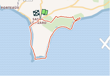

Length
7.1 km

Max alt
33 m

Uphill gradient
62 m
Km-Effort
7.9 km

Min alt
0 m

Downhill gradient
63 m
Boucle
Yes
Creation date :
2017-06-04 00:00:00.0
Updated on :
2017-06-04 00:00:00.0
1h45
Difficulty : Unknown

FREE GPS app for hiking
 SityTrail
IGN / Geographical institutes
SityTrail Plus
The world is yours!
About
Trail Walking of 7.1 km to be discovered at Normandy, Manche, Vains. This trail is proposed by cron.
Positioning
Country:
France
Region :
Normandy
Department/Province :
Manche
Municipality :
Vains
Location:
Unknown
Start:(Dec)
Start:(UTM)
614715 ; 5391941 (30U) N.
Comments