Trail Cycle Palavas-les-Flots - RP34 PALAVAS LES FLOTS -  VILLENEUVE LES MAGUELONE  - Photo

RP34 PALAVAS LES FLOTS - VILLENEUVE LES MAGUELONE

 jeff66
jeff66

User

© OpenStreetMap contributors
Length
Length
14.3 km
Max alt
Max alt
13 m
Uphill gradient
Uphill gradient
53 m
Km-Effort
Km-Effort  
15 km
Min alt
Min alt
-3 m
Downhill gradient
Downhill gradient
53 m
Boucle
Boucle
Yes
Creation date :
2017-06-05 00:00:00.0
Updated on :
2017-06-05 00:00:00.0

(0 Reviews)

Cycle
Cycle
2h58
Difficulty : Medium

Scan this QR Code to open this trail in the SityTrail application

FREE GPS app for hiking

Logo SityTrail SityTrail

IGN / Geographical institutes

Download SityTrail from the App Store Download SityTrail from Google Play

Logo SityTrail SityTrail Plus

The world is yours!

Download SityTrail from the App Store Download SityTrail from Google Play Download SityTrail on Huawei AppGallery

About

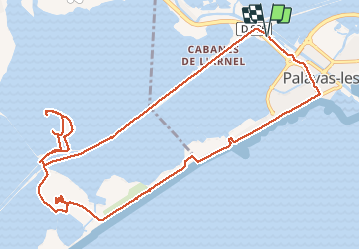
Trail Cycle of 14.3 km to be discovered at Occitania, Hérault, Palavas-les-Flots. This trail is proposed by jeff66.

Description

RP34 PALAVAS LES FLOTS -  VILLENEUVE LES MAGUELONE, les 4 canaux,
Les cabanes de l'Arrnel, les Pontils, passerelle du Pilou, l'Esclavon, Portail de Maguelone, cathédrale ST Pierre de Maguelone , la Sarrazine, PALAVAS, promenade ste catherine de la jacques Cartier, front de mer, institut ST pierre,  le 05.06.2017

Elevation profile

Positioning

Country:
France
Region :
Occitania
Department/Province :
Hérault
Municipality :
Palavas-les-Flots
Location:
Unknown
Start:(UTM)
574248 ; 4820414 (31T) N.


Close
My subscriptions