


l'étang d'or juin 2017

cemoi
User
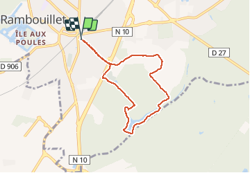

Length
6.6 km

Max alt
174 m

Uphill gradient
49 m
Km-Effort
7.2 km

Min alt
158 m

Downhill gradient
47 m
Boucle
Yes
Creation date :
2019-06-18 08:26:42.737
Updated on :
2020-04-24 08:02:01.1
1h22
Difficulty : Very easy

FREE GPS app for hiking
 SityTrail
IGN / Geographical institutes
SityTrail Plus
The world is yours!
About
Trail Walking of 6.6 km to be discovered at Ile-de-France, Yvelines, Rambouillet. This trail is proposed by cemoi.
Photos

Positioning
Country:
France
Region :
Ile-de-France
Department/Province :
Yvelines
Municipality :
Rambouillet
Location:
Unknown
Start:(Dec)
Start:(UTM)
413887 ; 5388308 (31U) N.
Comments