


ferrieres

FOUCHET
User
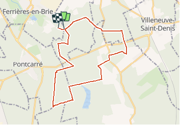

Length
16.7 km

Max alt
140 m

Uphill gradient
111 m
Km-Effort
18.2 km

Min alt
114 m

Downhill gradient
108 m
Boucle
No
Creation date :
2017-06-06 00:00:00.0
Updated on :
2017-06-06 00:00:00.0
--
Difficulty : Unknown

FREE GPS app for hiking
 SityTrail
IGN / Geographical institutes
SityTrail Plus
The world is yours!
About
Trail Walking of 16.7 km to be discovered at Ile-de-France, Seine-et-Marne, Ferrières-en-Brie. This trail is proposed by FOUCHET.
Positioning
Country:
France
Region :
Ile-de-France
Department/Province :
Seine-et-Marne
Municipality :
Ferrières-en-Brie
Location:
Unknown
Start:(Dec)
Start:(UTM)
479839 ; 5406789 (31U) N.
Comments