


rando la lieutenant 3

Sugg
User
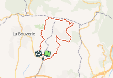

Length
17.2 km

Max alt
151 m

Uphill gradient
250 m
Km-Effort
21 km

Min alt
51 m

Downhill gradient
250 m
Boucle
Yes
Creation date :
2019-03-22 16:58:22.137
Updated on :
2022-03-13 20:04:48.005
6h37
Difficulty : Unknown

FREE GPS app for hiking
 SityTrail
IGN / Geographical institutes
SityTrail Plus
The world is yours!
About
Trail Walking of 17.2 km to be discovered at Provence-Alpes-Côte d'Azur, Var, Roquebrune-sur-Argens. This trail is proposed by Sugg.
Positioning
Country:
France
Region :
Provence-Alpes-Côte d'Azur
Department/Province :
Var
Municipality :
Roquebrune-sur-Argens
Location:
Unknown
Start:(Dec)
Start:(UTM)
311216 ; 4816704 (32T) N.
Comments