


F07300 Glun la Côte du Pape ST AM DP

ageo
User
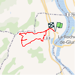

Length
6 km

Max alt
391 m

Uphill gradient
275 m
Km-Effort
9.7 km

Min alt
116 m

Downhill gradient
275 m
Boucle
Yes
Creation date :
2017-06-09 00:00:00.0
Updated on :
2017-06-09 00:00:00.0
2h00
Difficulty : Easy

FREE GPS app for hiking
 SityTrail
IGN / Geographical institutes
SityTrail Plus
The world is yours!
About
Trail Walking of 6 km to be discovered at Auvergne-Rhône-Alpes, Ardèche, Glun. This trail is proposed by ageo.

Positioning
Country:
France
Region :
Auvergne-Rhône-Alpes
Department/Province :
Ardèche
Municipality :
Glun
Location:
Unknown
Start:(Dec)
Start:(UTM)
644744 ; 4986417 (31T) N.
Comments