


foret fonblanche.gpx

georgein
User
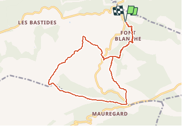

Length
10.1 km

Max alt
560 m

Uphill gradient
381 m
Km-Effort
15.2 km

Min alt
268 m

Downhill gradient
380 m
Boucle
Yes
Creation date :
2019-08-04 09:21:58.177
Updated on :
2020-01-31 20:31:59.196
--
Difficulty : Unknown

FREE GPS app for hiking
 SityTrail
IGN / Geographical institutes
SityTrail Plus
The world is yours!
About
Trail Walking of 10.1 km to be discovered at Provence-Alpes-Côte d'Azur, Bouches-du-Rhône, Roquefort-la-Bédoule. This trail is proposed by georgein.
Positioning
Country:
France
Region :
Provence-Alpes-Côte d'Azur
Department/Province :
Bouches-du-Rhône
Municipality :
Roquefort-la-Bédoule
Location:
Unknown
Start:(Dec)
Start:(UTM)
716745 ; 4792652 (31T) N.
Comments