Trail Walking Saint-Gildas-de-Rhuys - St-Gildas de Rhuys - Photo
© OpenStreetMap contributors
Length
Length
8.9 km
Max alt
Max alt
39 m
Uphill gradient
Uphill gradient
82 m
Km-Effort
Km-Effort  
10 km
Min alt
Min alt
0 m
Downhill gradient
Downhill gradient
83 m
Boucle
Boucle
Yes
Creation date :
2017-06-12 00:00:00.0
Updated on :
2017-06-12 00:00:00.0

(1 Reviews)

Walking
Walking
2h15
Difficulty : Medium

Scan this QR Code to open this trail in the SityTrail application

FREE GPS app for hiking

Logo SityTrail SityTrail

IGN / Geographical institutes

Download SityTrail from the App Store Download SityTrail from Google Play

Logo SityTrail SityTrail World

The world is yours!

Download SityTrail from the App Store Download SityTrail from Google Play Download SityTrail on Huawei AppGallery

About

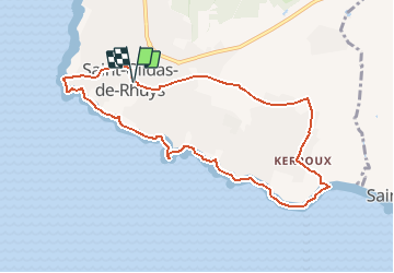
Trail Walking of 8.9 km to be discovered at Brittany, Morbihan, Saint-Gildas-de-Rhuys. This trail is proposed by neoroll44.

Description

Départ: place Monseigneur Ropert, près de l'église abbatiale Saint-Gildas.
Prendre la Rue des Vénètes, la suivre et continuer à gauche par la Route du Grand Mont. Bien marcher sur la partie aménagée pour les piétons. Dépasser le parking sur la droite et arriver au niveau du sémaphore.
GR34 : Balisage Blanc et Rouge.
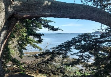
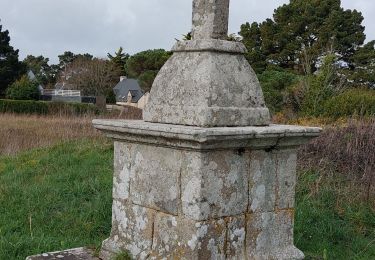
Tourner à gauche sur le sentier côtier vers la Pointe du Grand Mont. Vous êtes au point le plus élevé de la côte de la Presqu’île de Rhuys : superbe panorama avec sa table d’orientation et sa grande croix édifiée en hommage aux marins disparus en mer.
Poursuivre sur le sentier côtier orientation Sud-Sud-Est et atteindre la plage de Port Maria que l’on longe par le haut.
Arriver au petit port très pittoresque de Port aux Moines. Le contourner par la gauche et continuer en traversant l’aire de jeux avec des bancs. Virer à droite pour continuer sur le sentier côtier. Continuer jusqu’au Menhir de la Pierre Jaune situé en bordure de rivage. Poursuivre jusqu’au début de la Plage de Saint-Jacques.
Abandonner le GR et le bord de mer en virant à gauche dans un sentier qui mène à Kerroux. Rentrer dans une zone pavillonnaire et suivre les rues appelées chemins : Chemin du Ligno puis à droite Chemin de la Grande Vigne.
A la rencontre de la Route de Cossay, faire une baïonnette gauche-droite au niveau d’un rond-point et continuer dans le Chemin de Kerbistoul.
A un croisement avec panneaux directionnels, virer à gauche dans un sentier herbeux qui va rejoindre le Chemin de Poul Mare.
Traverser la Route de Kernolives et poursuivre tout droit. Dépasser la zone pavillonnaire pour continuer sur un nouveau chemin herbeux appelé Chemin de Sav Heol.
Rejoindre un nouveau groupe de maisons et continuer par le Chemin du Clos Castel. Ignorer toutes les rues tant à droite qu’à gauche. Dépasser des terrains de tennis situés à main droite puis virer à gauche (8) et ensuite à droite dans le Chemin des Dames.
Ce chemin longe le cimetière par la gauche puis l’église par la droite et arrive au parking de départ.

Elevation profile

Positioning

Country:
France
Region :
Brittany
Department/Province :
Morbihan
Municipality :
Saint-Gildas-de-Rhuys
Location:
Unknown
Start:(UTM)
512083 ; 5260753 (30T) N.

Comments

Please log in to post a review or rate the element


Trails nearby

Trail Walking Arzon - Tour du Golfe du Morbihan - 01 - Arzon - Photo
Walking
tracegps

Walking

Medium
(1)
Arzon, Brittany, Morbihan, France
18.9 km | 21 km-effort
4h 0min
No
Trail Walking Arzon - Tour du Golfe - Arzon - Photo
Walking
tracegps

Walking

Medium
(1)
Arzon, Brittany, Morbihan, France
18.2 km | 20 km-effort
4h 30min
Yes
Trail Walking Sarzeau - Sarzeau Saint Jacques - Saint Gildas de Rhuys - Photo
Walking
danieljpn

Walking

Easy
(1)
Sarzeau, Brittany, Morbihan, France
14.9 km | 16.4 km-effort
3h 38min
Yes
Trail Walking Sarzeau - Pointes de Bernon et de l'Ours - Photo
Walking
neoroll44

Walking

Medium
(2)
Sarzeau, Brittany, Morbihan, France
9.6 km | 10.8 km-effort
2h 22min
Yes
Trail Walking Sarzeau - Circuit du Château de Truscat - Photo
Walking
corsinou

Walking

Easy
(1)
Sarzeau, Brittany, Morbihan, France
7.4 km | 8.2 km-effort
1h 50min
Yes
Trail Other activity Saint-Gildas-de-Rhuys - Houat 1 - Photo
Other activity
PaulNord

Other activity

Very easy
(1)
Saint-Gildas-de-Rhuys, Brittany, Morbihan, France
18.2 km | 18.7 km-effort
4h 15min
No
Trail Walking Sarzeau - PR_56_Sarzeau_HA_08_Circuit1b_Les-Parcs-Ostreicoles_20240407 - Photo
Walking
patrickdanilo

Walking

Very easy
Sarzeau, Brittany, Morbihan, France
8.2 km | 9.2 km-effort
2h 5min
Yes
Trail Walking Sarzeau - PR_56_Sarzeau_GA_07_Circuit1b_Regards-Sur-Le-Golfe_20240310 - Photo
Walking
patrickdanilo

Walking

Very easy
Sarzeau, Brittany, Morbihan, France
8.3 km | 9.2 km-effort
2h 6min
Yes
Trail Walking Sarzeau - PR_56_Sarzeau_FA_06_Circuit1b_Le-Port-Du-Logeo_20240217 - Photo
Walking
patrickdanilo

Walking

Very easy
Sarzeau, Brittany, Morbihan, France
4.1 km | 4.6 km-effort
1h 3min
Yes


Close
My subscriptions