Trail Walking Saint-Vincent-de-Reins - saint-Vincent-de-Reins (21,9 km - D. 779 m) - Photo

saint-Vincent-de-Reins (21,9 km - D. 779 m)

© OpenStreetMap contributors
Length
Length
22 km
Max alt
Max alt
816 m
Uphill gradient
Uphill gradient
789 m
Km-Effort
Km-Effort  
32 km
Min alt
Min alt
561 m
Downhill gradient
Downhill gradient
786 m
Boucle
Boucle
Yes
Creation date :
2017-06-13 00:00:00.0
Updated on :
2017-06-13 00:00:00.0

(0 Reviews)

Walking
Walking
6h44
Difficulty : Medium

Scan this QR Code to open this trail in the SityTrail application

FREE GPS app for hiking

Logo SityTrail SityTrail

IGN / Geographical institutes

Download SityTrail from the App Store Download SityTrail from Google Play

Logo SityTrail SityTrail World

The world is yours!

Download SityTrail from the App Store Download SityTrail from Google Play Download SityTrail on Huawei AppGallery

About

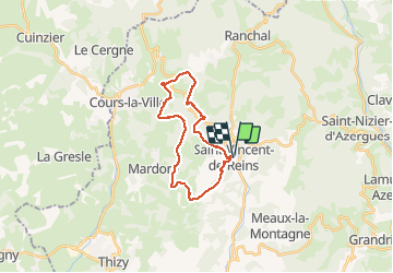
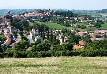
Trail Walking of 22 km to be discovered at Auvergne-Rhône-Alpes, Rhône, Saint-Vincent-de-Reins. This trail is proposed by Thomasdanielle.

Description

Départ Eglise/mairie
22 km- D. 779 m
Attention : éviter de monter en direction Le Pernin, le sentier indiqué à droite est impraticable et fermer par des prairies de vache et des barbelés. A la croix prendre le chemin hameau Lespinasse est suivre le tracet du GPS pour arriver jusqu'à Le REPLAT et au Fouilloux.
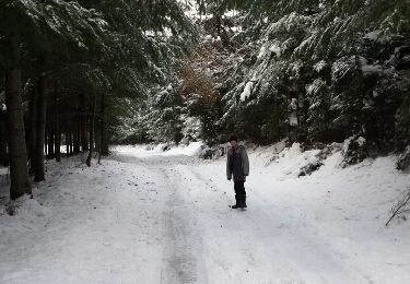
Elevation profile

Photos

Positioning

Country:
France
Region :
Auvergne-Rhône-Alpes
Department/Province :
Rhône
Municipality :
Saint-Vincent-de-Reins
Location:
Unknown
Start:(UTM)
607421 ; 5103286 (31T) N.

Trails nearby

Trail Mountain bike Cours - VTT autour de Thel et Ranchal - Cours la Ville - Photo
Mountain bike
tracegps

Mountain bike

Difficult
(1)
Cours, Auvergne-Rhône-Alpes, Rhône, France
26 km | 37 km-effort
3h 0min
Yes
Trail Walking Ranchal - Col de favardy - Photo
Walking
redtek

Walking

Easy
Ranchal, Auvergne-Rhône-Alpes, Rhône, France
8.7 km | 12.6 km-effort
2h 39min
Yes
Trail Walking Saint-Bonnet-le-Troncy - rançon 2 - Photo
Walking
redtek

Walking

Easy
Saint-Bonnet-le-Troncy, Auvergne-Rhône-Alpes, Rhône, France
5.4 km | 7.9 km-effort
1h 39min
Yes
Trail Walking Saint-Bonnet-le-Troncy - petit radar - Photo
Walking
redtek

Walking

Medium
Saint-Bonnet-le-Troncy, Auvergne-Rhône-Alpes, Rhône, France
6.3 km | 10.2 km-effort
1h 53min
Yes
Trail Mountain bike Thizy-les-Bourgs - Rando VTT Thizy Lac des Sapins (2012) - Marnand - Photo
Mountain bike
tracegps

Mountain bike

Very difficult
Thizy-les-Bourgs, Auvergne-Rhône-Alpes, Rhône, France
62 km | 87 km-effort
5h 15min
Yes
Trail Mountain bike Thizy-les-Bourgs - VTT - Thizy / Lac des Sapins 2011-70 km - Marnand - Photo
Mountain bike
tracegps

Mountain bike

Difficult
Thizy-les-Bourgs, Auvergne-Rhône-Alpes, Rhône, France
68 km | 96 km-effort
5h 0min
Yes
Trail Walking Meaux-la-Montagne - Meaux-La-Montagne (16 km - D. 670 m) - Photo
Walking
Thomasdanielle

Walking

Very difficult
Meaux-la-Montagne, Auvergne-Rhône-Alpes, Rhône, France
16.4 km | 25 km-effort
5h 46min
Yes
Trail Walking Saint-Bonnet-le-Troncy - 15 km - Photo
Walking
GRANJAC

Walking

Very difficult
Saint-Bonnet-le-Troncy, Auvergne-Rhône-Alpes, Rhône, France
15 km | 24 km-effort
5h 24min
Yes
Trail Walking Cours - thel - Photo
Walking
tomalilou

Walking

Very difficult
Cours, Auvergne-Rhône-Alpes, Rhône, France
20 km | 30 km-effort
6h 52min
Yes


Close
My subscriptions