


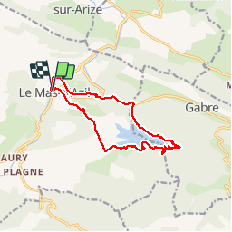
Mas d'Azil lac de Filliet

pidjam
User

Length
13.3 km

Max alt
409 m

Uphill gradient
224 m
Km-Effort
16.2 km

Min alt
280 m

Downhill gradient
225 m
Boucle
Yes
Creation date :
2017-06-16 00:00:00.0
Updated on :
2017-06-16 00:00:00.0
3h23
Difficulty : Unknown

FREE GPS app for hiking
 SityTrail
IGN / Geographical institutes
SityTrail Plus
The world is yours!
About
Trail Walking of 13.3 km to be discovered at Occitania, Ariège, Le Mas-d'Azil. This trail is proposed by pidjam.
Description
Au départ et à l'arrivée un peu de route sous les pieds, mais le reste est dans les bois, autour du lac, très joli (quelques passages boueux à prévoir).
Photos


Positioning
Country:
France
Region :
Occitania
Department/Province :
Ariège
Municipality :
Le Mas-d'Azil
Location:
Unknown
Start:(Dec)
Start:(UTM)
366558 ; 4770960 (31T) N.
Comments