


neuviller les savernes

oscar1
User
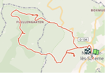

Length
14.1 km

Max alt
410 m

Uphill gradient
542 m
Km-Effort
21 km

Min alt
209 m

Downhill gradient
542 m
Boucle
Yes
Creation date :
2017-11-04 00:00:00.0
Updated on :
2019-01-20 22:32:11.172
4h48
Difficulty : Medium

FREE GPS app for hiking
 SityTrail
IGN / Geographical institutes
SityTrail Plus
The world is yours!
About
Trail Walking of 14.1 km to be discovered at Grand Est, Bas-Rhin, Neuwiller-lès-Saverne. This trail is proposed by oscar1.
Positioning
Country:
France
Region :
Grand Est
Department/Province :
Bas-Rhin
Municipality :
Neuwiller-lès-Saverne
Location:
Unknown
Start:(Dec)
Start:(UTM)
382910 ; 5409055 (32U) N.
Comments