


Poperinge-Watou (PVDB)

Peter.vdbergh
User GUIDE
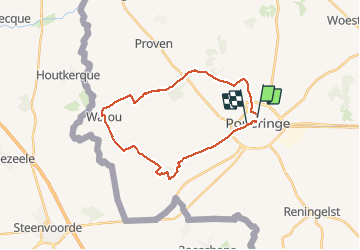

Length
23 km

Max alt
70 m

Uphill gradient
168 m
Km-Effort
25 km

Min alt
12 m

Downhill gradient
172 m
Boucle
No
Creation date :
2017-06-19 00:00:00.0
Updated on :
2020-07-24 13:33:04.119
--
Difficulty : Unknown

FREE GPS app for hiking
 SityTrail
IGN / Geographical institutes
SityTrail Plus
The world is yours!
About
Trail Walking of 23 km to be discovered at Flanders, West Flanders, Poperinge. This trail is proposed by Peter.vdbergh.
Positioning
Country:
Belgium
Region :
Flanders
Department/Province :
West Flanders
Municipality :
Poperinge
Location:
Poperinge
Start:(Dec)
Start:(UTM)
480750 ; 5634042 (31U) N.
Comments