


Roz sur Couesnon-Dol de Bretagne

henzmannp
User
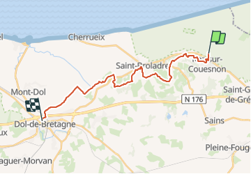

Length
21 km

Max alt
92 m

Uphill gradient
305 m
Km-Effort
25 km

Min alt
-1 m

Downhill gradient
296 m
Boucle
No
Creation date :
2017-06-22 00:00:00.0
Updated on :
2017-06-22 00:00:00.0
7h00
Difficulty : Unknown

FREE GPS app for hiking
 SityTrail
IGN / Geographical institutes
SityTrail Plus
The world is yours!
About
Trail Other activity of 21 km to be discovered at Brittany, Ille-et-Vilaine, Roz-sur-Couesnon. This trail is proposed by henzmannp.
Positioning
Country:
France
Region :
Brittany
Department/Province :
Ille-et-Vilaine
Municipality :
Roz-sur-Couesnon
Location:
Unknown
Start:(Dec)
Start:(UTM)
603981 ; 5383421 (30U) N.
Comments