Trail Walking La Voulte-sur-Rhône - ardeche 2 - Photo

partout a pied et en moto

© OpenStreetMap contributors
Length
Length
131 km
Max alt
Max alt
1301 m
Uphill gradient
Uphill gradient
4009 m
Km-Effort
Km-Effort  
183 km
Min alt
Min alt
93 m
Downhill gradient
Downhill gradient
3564 m
Boucle
Boucle
No
Creation date :
2019-01-14 09:43:03.561
Updated on :
2019-01-14 09:43:03.708

(0 Reviews)

Walking
Walking
35h33
Difficulty : Unknown

Scan this QR Code to open this trail in the SityTrail application

FREE GPS app for hiking

Logo SityTrail SityTrail

IGN / Geographical institutes

Download SityTrail from the App Store Download SityTrail from Google Play

Logo SityTrail SityTrail Plus

The world is yours!

Download SityTrail from the App Store Download SityTrail from Google Play Download SityTrail on Huawei AppGallery

About

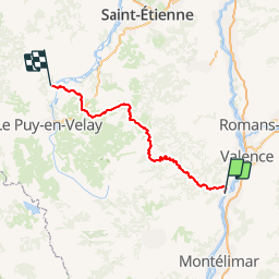
Trail Walking of 131 km to be discovered at Auvergne-Rhône-Alpes, Ardèche, La Voulte-sur-Rhône. This trail is proposed by les randos d'Olivier.

Elevation profile

Points of interest

Point of interest Saint-Laurent-du-Pape - parking 1 - Photo
olivieraron
SAINT-LAURENT-DU-PAPE 
Point of interest Saint-Michel-de-Chabrillanoux - end day 1 - Photo
olivieraron
SAINT-MICHEL-DE-CHABRILLANOUX 
Point of interest Belsentes - park 2 - Photo
olivieraron
BELSENTES 
Point of interest Saint-Martin-de-Valamas - end day 2 - Photo
olivieraron
SAINT-MARTIN-DE-VALAMAS 
Point of interest Saint-Agrève - park day 3 - Photo
olivieraron
SAINT-AGRÈVE 
Point of interest Tence - end day 3 - Photo
olivieraron
TENCE 

Positioning

Country:
France
Region :
Auvergne-Rhône-Alpes
Department/Province :
Ardèche
Municipality :
La Voulte-sur-Rhône
Location:
Unknown
Start:(Dec)
Start:(UTM)
640836 ; 4962231 (31T) N.


Close
My subscriptions