


sainte christine 2 (10km)

olaze
User
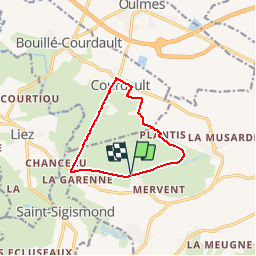

Length
9.5 km

Max alt
12 m

Uphill gradient
53 m
Km-Effort
10.2 km

Min alt
0 m

Downhill gradient
53 m
Boucle
Yes
Creation date :
2017-06-28 00:00:00.0
Updated on :
2017-06-28 00:00:00.0
2h30
Difficulty : Easy

FREE GPS app for hiking
 SityTrail
IGN / Geographical institutes
SityTrail Plus
The world is yours!
About
Trail Other activity of 9.5 km to be discovered at Pays de la Loire, Vendée, Benet. This trail is proposed by olaze.
Positioning
Country:
France
Region :
Pays de la Loire
Department/Province :
Vendée
Municipality :
Benet
Location:
Unknown
Start:(Dec)
Start:(UTM)
679557 ; 5136694 (30T) N.
Comments
Sainte christine 2