


droue sur drouette

topophil
User
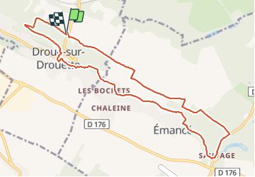

Length
10.4 km

Max alt
168 m

Uphill gradient
128 m
Km-Effort
12.1 km

Min alt
121 m

Downhill gradient
127 m
Boucle
Yes
Creation date :
2017-06-29 00:00:00.0
Updated on :
2017-06-29 00:00:00.0
2h16
Difficulty : Unknown

FREE GPS app for hiking
 SityTrail
IGN / Geographical institutes
SityTrail Plus
The world is yours!
About
Trail Walking of 10.4 km to be discovered at Centre-Loire Valley, Eure-et-Loir, Droue-sur-Drouette. This trail is proposed by topophil.
Positioning
Country:
France
Region :
Centre-Loire Valley
Department/Province :
Eure-et-Loir
Municipality :
Droue-sur-Drouette
Location:
Unknown
Start:(Dec)
Start:(UTM)
404493 ; 5384366 (31U) N.
Comments