


Holsbeek

JanBekaert
User
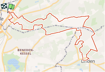

Length
14.2 km

Max alt
86 m

Uphill gradient
263 m
Km-Effort
17.8 km

Min alt
14 m

Downhill gradient
264 m
Boucle
Yes
Creation date :
2017-07-02 00:00:00.0
Updated on :
2017-07-02 00:00:00.0
4h21
Difficulty : Easy

FREE GPS app for hiking
 SityTrail
IGN / Geographical institutes
SityTrail Plus
The world is yours!
About
Trail Walking of 14.2 km to be discovered at Flanders, Flemish Brabant, Holsbeek. This trail is proposed by JanBekaert.
Description
heuve¨l bos
Photos

Positioning
Country:
Belgium
Region :
Flanders
Department/Province :
Flemish Brabant
Municipality :
Holsbeek
Location:
Holsbeek
Start:(Dec)
Start:(UTM)
620897 ; 5641623 (31U) N.
Comments