Trail Walking Saint-Amant-Roche-Savine - St_Amant_Roche_Savine - Photo
 jagarnier
jagarnier

User GUIDE

© OpenStreetMap contributors
Length
Length
12.1 km
Max alt
Max alt
1083 m
Uphill gradient
Uphill gradient
492 m
Km-Effort
Km-Effort  
18.6 km
Min alt
Min alt
796 m
Downhill gradient
Downhill gradient
496 m
Boucle
Boucle
Yes
Creation date :
2017-07-03 00:00:00.0
Updated on :
2022-04-11 06:04:52.101

(0 Reviews)

Walking
Walking
3h52
Difficulty : Medium

Scan this QR Code to open this trail in the SityTrail application

FREE GPS app for hiking

Logo SityTrail SityTrail

IGN / Geographical institutes

Download SityTrail from the App Store Download SityTrail from Google Play

Logo SityTrail SityTrail World

The world is yours!

Download SityTrail from the App Store Download SityTrail from Google Play Download SityTrail on Huawei AppGallery

About

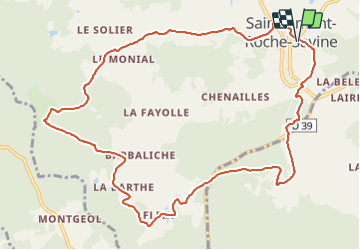
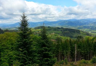
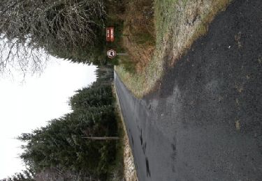
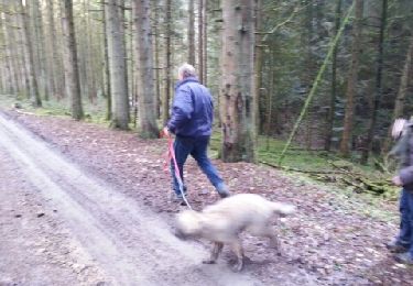
Trail Walking of 12.1 km to be discovered at Auvergne-Rhône-Alpes, Puy-de-Dôme, Saint-Amant-Roche-Savine. This trail is proposed by jagarnier.

Description

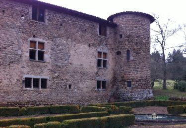
Cette randonnée vous permet de suivre la trace des "Pelharots", chiffonniers qui, de ferme en ferme vendaient leur collecte aux tisserands et papetiers. Au sud du château de Roche-Savine, vous verrez le bassin de Virennes, véritable conservatoire forestier où vous pourrez découvrir différentes essences comme l’épicéa, le hêtre ou encore l’orme.

Elevation profile

Photos

Positioning

Country:
France
Region :
Auvergne-Rhône-Alpes
Department/Province :
Puy-de-Dôme
Municipality :
Saint-Amant-Roche-Savine
Location:
Unknown
Start:(UTM)
549381 ; 5046982 (31T) N.

Trails nearby

Trail On foot Le Monestier - Les Communaux de l'Achant - Photo
On foot
PRO

On foot

Medium
Le Monestier, Auvergne-Rhône-Alpes, Puy-de-Dôme, France
14.4 km | 20 km-effort
4h 37min
No
Trail On foot Saint-Amant-Roche-Savine - Roche-Savine - Photo
On foot
PRO

On foot

Easy
Saint-Amant-Roche-Savine, Auvergne-Rhône-Alpes, Puy-de-Dôme, France
12.1 km | 18.7 km-effort
4h 15min
Yes
Trail On foot Fournols - Les Deux-Frères - Photo
On foot
PRO

On foot

Easy
Fournols, Auvergne-Rhône-Alpes, Puy-de-Dôme, France
12.2 km | 16.8 km-effort
3h 48min
Yes
Trail On foot Saint-Ferréol-des-Côtes - Le Ruisseau des Escures - Photo
On foot
PRO

On foot

Medium
Saint-Ferréol-des-Côtes, Auvergne-Rhône-Alpes, Puy-de-Dôme, France
17.5 km | 25 km-effort
5h 46min
No
Trail On foot Le Monestier - Les Lèches Beurriers - Photo
On foot
PRO

On foot

Easy
Le Monestier, Auvergne-Rhône-Alpes, Puy-de-Dôme, France
6.8 km | 10.5 km-effort
2h 23min
Yes
Trail On foot Saint-Amant-Roche-Savine - Aux Sources de La Dolore - Photo
On foot
PRO

On foot

Easy
Saint-Amant-Roche-Savine, Auvergne-Rhône-Alpes, Puy-de-Dôme, France
7.6 km | 9.3 km-effort
2h 6min
Yes
Trail On foot La Chapelle-Agnon - Le Bois de Pierre Blanche - Photo
On foot
PRO

On foot

Easy
La Chapelle-Agnon, Auvergne-Rhône-Alpes, Puy-de-Dôme, France
9 km | 12.9 km-effort
2h 55min
Yes
Trail Walking Saint-Éloy-la-Glacière - st eloy - chalembel  - Photo
Walking
fredspa

Walking

Medium
Saint-Éloy-la-Glacière, Auvergne-Rhône-Alpes, Puy-de-Dôme, France
8.6 km | 10.2 km-effort
2h 13min
No
Trail Walking Le Monestier - Le Monest - Photo
Walking
fredspa

Walking

Easy
Le Monestier, Auvergne-Rhône-Alpes, Puy-de-Dôme, France
8.4 km | 10.6 km-effort
2h 7min
No


Close
My subscriptions