


Propière (la poste)

Thomasdanielle
User
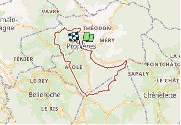

Length
15.3 km

Max alt
961 m

Uphill gradient
505 m
Km-Effort
22 km

Min alt
550 m

Downhill gradient
508 m
Boucle
Yes
Creation date :
2017-07-06 00:00:00.0
Updated on :
2021-06-18 14:03:02.025
4h03
Difficulty : Easy

FREE GPS app for hiking
 SityTrail
IGN / Geographical institutes
SityTrail Plus
The world is yours!
About
Trail Walking of 15.3 km to be discovered at Auvergne-Rhône-Alpes, Rhône, Propières. This trail is proposed by Thomasdanielle.
Description
D/A parking "La Poste"
Positioning
Country:
France
Region :
Auvergne-Rhône-Alpes
Department/Province :
Rhône
Municipality :
Propières
Location:
Unknown
Start:(Dec)
Start:(UTM)
610921 ; 5116260 (31T) N.
Comments