apremont 60300

dartoisclaude
User
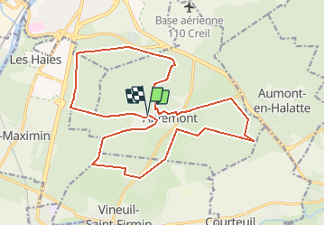

Length
20 km

Max alt
134 m

Uphill gradient
210 m
Km-Effort
23 km

Min alt
59 m

Downhill gradient
203 m
Boucle
Yes
Creation date :
2017-07-19 00:00:00.0
Updated on :
2017-07-19 00:00:00.0
4h49
Difficulty : Difficult

FREE GPS app for hiking
 SityTrail
IGN / Geographical institutes
SityTrail Plus
The world is yours!
About
Trail Walking of 20 km to be discovered at Hauts-de-France, Oise, Apremont. This trail is proposed by dartoisclaude.
Description
APREMONT 60300 Grand parcours
Positioning
Country:
France
Region :
Hauts-de-France
Department/Province :
Oise
Municipality :
Apremont
Location:
Unknown
Start:(Dec)
Start:(UTM)
463807 ; 5452617 (31U) N.
Comments