


Forêt de Montargis

Ordijamo45
User
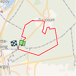

Length
12.8 km

Max alt
141 m

Uphill gradient
92 m
Km-Effort
14.1 km

Min alt
106 m

Downhill gradient
93 m
Boucle
Yes
Creation date :
2019-05-03 09:14:44.667
Updated on :
2019-05-03 09:14:44.738
3h07
Difficulty : Very easy

FREE GPS app for hiking
 SityTrail
IGN / Geographical institutes
SityTrail Plus
The world is yours!
About
Trail Walking of 12.8 km to be discovered at Centre-Loire Valley, Loiret, Chalette-sur-Loing. This trail is proposed by Ordijamo45.
Description
Départ carrefour de l'Europe
Positioning
Country:
France
Region :
Centre-Loire Valley
Department/Province :
Loiret
Municipality :
Chalette-sur-Loing
Location:
Unknown
Start:(Dec)
Start:(UTM)
482115 ; 5317645 (31U) N.
Comments