


67 ALBE

LUTZMarc
User
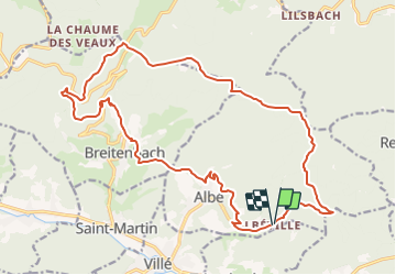

Length
21 km

Max alt
887 m

Uphill gradient
850 m
Km-Effort
33 km

Min alt
315 m

Downhill gradient
855 m
Boucle
Yes
Creation date :
2017-07-27 00:00:00.0
Updated on :
2017-07-27 00:00:00.0
5h50
Difficulty : Medium

FREE GPS app for hiking
 SityTrail
IGN / Geographical institutes
SityTrail Plus
The world is yours!
About
Trail Walking of 21 km to be discovered at Grand Est, Bas-Rhin, Albé. This trail is proposed by LUTZMarc.
Description
Marche de montagne .
Positioning
Country:
France
Region :
Grand Est
Department/Province :
Bas-Rhin
Municipality :
Albé
Location:
Unknown
Start:(Dec)
Start:(UTM)
377000 ; 5356640 (32U) N.
Comments