


LUZARCHES BOUCLE 17 KM

gemau77
User
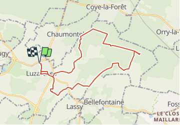

Length
17 km

Max alt
138 m

Uphill gradient
273 m
Km-Effort
21 km

Min alt
44 m

Downhill gradient
273 m
Boucle
Yes
Creation date :
2019-03-18 15:03:48.659
Updated on :
2022-03-20 20:39:10.701
4h14
Difficulty : Unknown

FREE GPS app for hiking
 SityTrail
IGN / Geographical institutes
SityTrail Plus
The world is yours!
About
Trail Walking of 17 km to be discovered at Ile-de-France, Val-d'Oise, Luzarches. This trail is proposed by gemau77.

Positioning
Country:
France
Region :
Ile-de-France
Department/Province :
Val-d'Oise
Municipality :
Luzarches
Location:
Unknown
Start:(Dec)
Start:(UTM)
457773 ; 5440636 (31U) N.
Comments