


2017-07-22 Sortie Canoë avec Rosheim Running

holtzv
User GUIDE
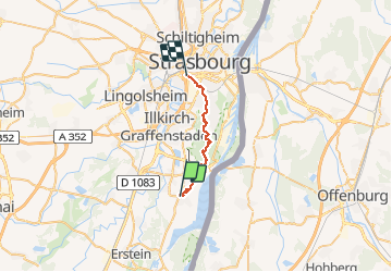

Length
19.6 km

Max alt
152 m

Uphill gradient
133 m
Km-Effort
21 km

Min alt
135 m

Downhill gradient
137 m
Boucle
No
Creation date :
2017-07-22 00:00:00.0
Updated on :
2017-07-22 00:00:00.0
5h46
Difficulty : Very easy

FREE GPS app for hiking
 SityTrail
IGN / Geographical institutes
SityTrail Plus
The world is yours!
About
Trail Other activity of 19.6 km to be discovered at Grand Est, Bas-Rhin, Plobsheim. This trail is proposed by holtzv.
Positioning
Country:
France
Region :
Grand Est
Department/Province :
Bas-Rhin
Municipality :
Plobsheim
Location:
Unknown
Start:(Dec)
Start:(UTM)
405885 ; 5369396 (32U) N.
Comments