


conques

phila128
User
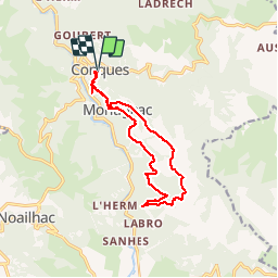

Length
13.4 km

Max alt
606 m

Uphill gradient
518 m
Km-Effort
20 km

Min alt
241 m

Downhill gradient
514 m
Boucle
Yes
Creation date :
2017-07-24 00:00:00.0
Updated on :
2017-07-24 00:00:00.0
1h58
Difficulty : Unknown

FREE GPS app for hiking
 SityTrail
IGN / Geographical institutes
SityTrail Plus
The world is yours!
About
Trail Walking of 13.4 km to be discovered at Occitania, Aveyron, Conques-en-Rouergue. This trail is proposed by phila128.
Positioning
Country:
France
Region :
Occitania
Department/Province :
Aveyron
Municipality :
Conques-en-Rouergue
Location:
Unknown
Start:(Dec)
Start:(UTM)
452181 ; 4938600 (31T) N.
Comments