


VertGalantS031217

fmg
User
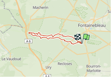

Length
22 km

Max alt
143 m

Uphill gradient
351 m
Km-Effort
27 km

Min alt
73 m

Downhill gradient
349 m
Boucle
Yes
Creation date :
2017-12-03 00:00:00.0
Updated on :
2017-12-03 00:00:00.0
12m
Difficulty : Unknown

FREE GPS app for hiking
 SityTrail
IGN / Geographical institutes
SityTrail Plus
The world is yours!
About
Trail Walking of 22 km to be discovered at Ile-de-France, Seine-et-Marne, Fontainebleau. This trail is proposed by fmg.

Positioning
Country:
France
Region :
Ile-de-France
Department/Province :
Seine-et-Marne
Municipality :
Fontainebleau
Location:
Unknown
Start:(Dec)
Start:(UTM)
476295 ; 5358276 (31U) N.
Comments